Meers
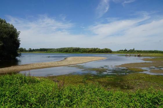
The Netherlands’ one and only white water river lives up to this title in Meers. This has always been one of the most dynamic stretches of the Meuse. The river has a sudden and sharp decline here which results in a spectacular increase in current. This has created a landscape with natural gravel ridges, spectacular erosion gullies, and a peninsula with riparian forest. Until 2008, Meers served as a test project for the Grensmaas water safety and development project but has since become a leading example for other areas. Animals and plants are feeling more at home in this new wilderness. Plant species such as oregano (wild marjoram) and wild thyme have returned to the region. Along the eroding banks sand martins build their nests and the common kingfisher can be seen gliding effortlessly above the water. The most noteworthy success story has been the return of the beaver, which has made this area its home once again. Migratory birds are also becoming more enchanted by the natural surroundings of the Meuse Valley.
Meers lies on the bank of the Meuse where the river meanders around the village. The construction of the Juliana Canal in the 1930s isolated Meers between the canal and the river. The village is connected to Stein by a bridge. In order to reduce the risk of floods, the main channel of the river is being widened and the banks are being lowered. This creates a new large uninterrupted nature reserve of more than 1,000 hectares. In Meers there is already a small-scale indication of how the Grensmaas area will look in the future: a beautiful natural environment with a river that has the space to flow.
Discover RivierPark Maasvallei in Meers
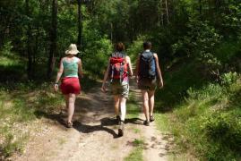
No trails or walking routes have been laid out in this nature reserve. The large grazers create natural trails that walkers can explore. You can roam off-trail in this area. Konik horses and Galloway cattle roam wild in this area and play an important part in managing the environment. They ensure that open and grassy sections are alternated with bushes and forests. Please do not feed or pet the animals, and keep a distance of at least 25 metres. Dogs must be kept on a leash. You can access the area through the swing gates. Café de Witte Börstel, Koevaart 15 in Meers is the best starting point from which to explore this area.
Walking and cycling in Stein municipality
Stein municipality has many sites that are worth seeing and several walking and cycling routes to explore. Click here to download the free walking and cycling brochure Sprankelend Stein from the South Limburg tourist information offices (VVV Zuid-Limburg) that shows five walking routes and one cycling route. If you want to experience the thrill of the Meuse, be sure to go rafting or canoeing. Click here for more information about the activities and sites to see in Stein.
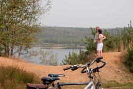
Junction system for cycling routes
Discover RivierPark Maasvallei by bicycle. The practical junction network for cycling routes allows you to plan your route with the relevant numbers before your trip. When you embark on your cycling trip, all you need to do is follow the numbers that you have selected. The distances between the junctions are also clearly marked allowing you to plan routes between the junctions. The Dutch cycling routes junctions connect directly with those in Belgium. The maps for the network are available at all South Limburg tourist information offices (VVV Zuid-Limburg). You can also order the map of the cycling routes junctions at our online shop.
Stunning Stein
The lush Stein municipality which consists of Elsloo, Meers, Stein, Urmond, and Berg aan de Maas is a true walking and cycling paradise. Many different junctions of the extensive Dutch network of cycling routes can be found here. These routes connect to the Belgian network of cycling routes with the Europabrug bridge and the ferry in Berg aan de Maas. Belgium lies just across the Meuse. The river forms a natural border between the Netherlands and Belgium but there are few cultural differences between Stein and its neighbouring country.
Woodhenge & Maasband water station
Woodhenge
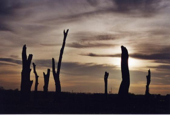
Fifteen black tree stumps can be seen in Meerser Koegriend along the Meuse that might make you think that there was a forest fire here at some point in the distant past. However, history tells a different tale. These tree stumps are approximately 1,400 to 1,700 years old and are part of a new monument called ‘Woodhenge’. These fossilized black tree stumps were uncovered during gravel extraction activities in the region and placed here as a monument and point of reference. A flat Meuse stone has been placed in the centre of the monument with an explanation about the positioning of the stumps in relation to the movement of the sun.
Maasband water station
Tap water is a good, healthy, and cheap thirst quencher. During the summer months you can find a water station in Maasband on the corner of Leutherhoekweg/Maasbanderkerkweg. Walkers, pets, tourists, and cyclists are free to fill their water bottles here and to take a moment to enjoy the beautiful view of the Meuse that this location offers. During the winter months, the water station is removed to prevent damage caused by frost and to perform maintenance.
Berg aan de Maas ferry
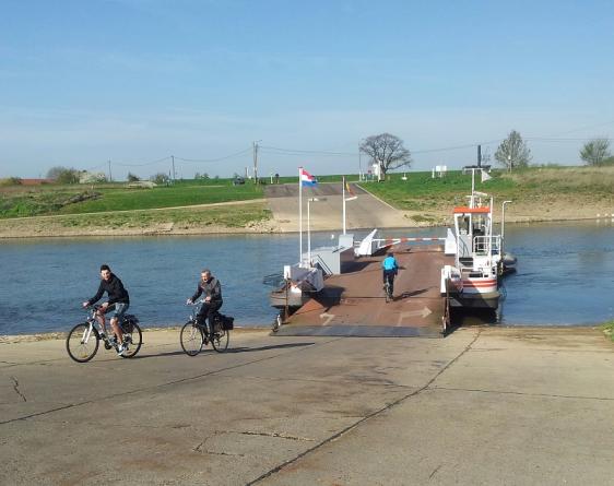
As the name explains in Dutch, this village is located next to the Meuse (literally the name of the village means Mountain next to the Meuse). The village dates back to the sixteenth century when it was a parish with its own church. In 2007 the village numbered 2,050 residents while the connected settlement of Nattenhoven only counts about 170 residents. In the past, Berg aan de Maas has been the victim of several floods. Since the completion of the Juliana Canal east of the village in the 1930s, Berg aan de Maas has been bordered by two large streams. Berg aan de Maas is mainly known for its ferry service. This connection allows cyclists and walkers to easily cross the Meuse to Belgium and is used by many visitors on the weekends and during holidays. The cafés with their sun-drenched outdoor terraces have a lively atmosphere. Berg aan de Maas is the starting point for many walking and cycling routes. Click here for more information about the operating hours and locations of the ferries.
Visit Stein!
Maan de Maaskanter: your local ‘guide’
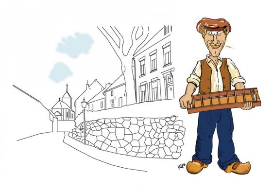
Now that the Grensmaas ('border Meuse') region is becoming a tourist hotspot, many visitors are discovering the unique combination of stunning landscapes, historic centres, and beautiful nature that the Meuse Valley offers. Nearly all the popular cycling and walking routes pass through this area because of the spectacular variety of things to see and do here. At Stein, the Meuse Valley creates the connecting point between the two opposite banks for the cycling routes junctions and the Green Metropolis Leisure Route. If you prefer not to get lost on your walk or cycling tour, you will need a guide. Iconic Maan de Maaskanter (Herman of the Meuse) will be your guide in this area. You will encounter Maan along your routes. He points you in the right direction and knows everything about local cuisine and locally-brewed beers. He also contributes a few special tips on the menus of some of the local cafés and restaurants. The name ‘Maan’ is a shortened version of the common regional name 'Herman’. Maan de Maaskanter is a symbol for the characteristic Meuse-region resident: a real go-getter with a stubborn personality who can also enjoy the brighter things in life. For centuries, these people have fought against the rising waters of the Meuse and earned their living as farmers and brickmakers. Maan holds one of the tools that were vital for this trade: the brick mould. At his feet flows the water of the Meuse, a river with which he has a complex ‘love-hate’ relationship. Maan will show you why he has a strong connection to the Meuse Valley.